Country wide 8cm TrueOrtho and DSM
Introduction
In this blog, we explain why and how we created a country wide 8cm TrueOrtho and DSM (Elevation map) from aerial imagery. The elevation map and TrueOrtho are available for download and through our API.
Aerial imagery as open data
Starting this year, the 8cm high resolution aerial photo from beeldmateriaal.nl is open data. Earlier, the 25cm aerial photo and the LiDAR dataset Algemeen Hoogtebestand Nederland (AHN) were already made open data. We warmly welcome this for two reasons:
- Efficiency: We analyze a lot of aerial images for municipalities, environmental services and provinces and it often takes a lot of time to get those aerial photos available. Think of: finding the right contact person, signing a processing agreement, uploading several terabytes of data or sending a hard disk. So we are trying to get more and more of our clients to use the 8cm, it saves a lot of work for everyone.
- Country wide products: The national aerial imagery provides an opportunity to develop national data products. From this dataset we can improve existing products such as our solar panel database as we are now able to use 8cm photos instead of 25cm. We will also launch new products, such as a country-wide elevation model and TrueOrtho imagery.
A country wide height model (DSM) from imagery
Why are we creating an elevation map?
The Algemeen Hoogtebestand Nederland has been open data for a few years now and it is now used for all kinds of applications, such as:
- Environmental noise studies
- 3D city models
- Potential for solar energy
- Water management and flood modeling
AHN is collected using a laser scanner (LiDAR). Collection takes about 3 years and it takes about a year after collection until the data becomes available. That means the data is up to 4 years old. Currently, AHN 3 is largely still in use, the oldest pieces of it even dating back to 2014.
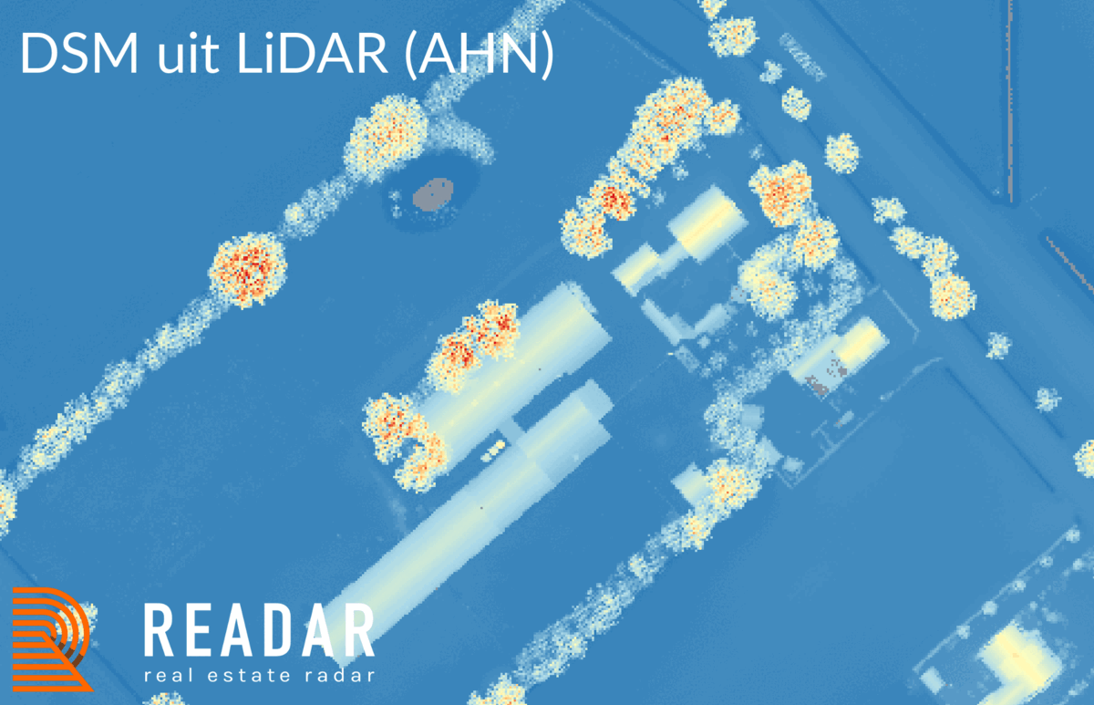
Advantages of a height model from imagery versus LiDAR
From aerial imagery we can generate an elevation map by means of dense matching. This has several advantages over the available LiDAR data; it is more recent in date, namely: spring 2021. Moreover, there is no time difference between the aerial imagery and the elevation map: what you can see in the aerial photo is in the elevation model and vice versa. In addition, it has a much higher resolution. AHN has a resolution of 50cm (sampled from 8-12 laser points per m2), our elevation model has a resolution of 8cm (156 points per m2).
How do we create the elevation map from an aerial photograph?
By using overlapping aerial photos, we can use the stereo image to create an elevation map. The generation of the elevation map (or Digital Surface Model, DSM) is done using a neural network (CNN). This achieves maximum data coverage at high elevation accuracy. The height accuracy thus obtained is comparable to competing techniques based on semi global matching (SGM). The coverage of our CNN solution is significantly higher.
To determine the elevation accuracy independently, we compared the elevation model of the CNN with an elevation model based on laser data (AHN3). The aerial photographs and laser data were acquired completely independently (separate flights). Our CNN elevation model used for this measurement was generated from aerial photos with 10cm ground resolution. The laser data file has a known and checked elevation accuracy of better than 5cm stochastic (1-sigma) + 5cm systematic. If the height model from the CNN is subtracted from the laser height model, we obtain a probability density graph. The middle value of the deviation is 8.5 cm. It is unknown how much of this is caused by the systematic deviation in the AHN (up to 5cm). 95% of the data points are within 13 cm of the median value. To exclude the influence of planimetric errors (up to about 50cm in the laser file), only data points were compared on surfaces with a slope of less than 45 degrees.
Based on aerial images with 10cm ground resolution and an overlap of 60% forward and 30% sideways, a coverage of 97% over the entire terrain and 98% within buildings is obtained. Coverage was calculated based on an elevation model with 10cm ground resolution.
Nationwide TrueOrtho imagery
Why do we create a True Ortho?
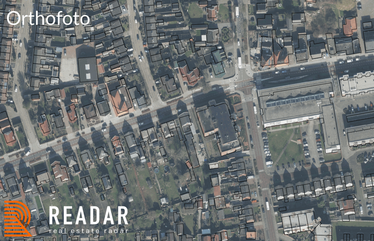
The best-known application of aerial photos is probably the Orthophoto: see, for example, the “satellite” view from Google Maps. From stereo images, we can generate a TrueOrtho through dense matching. A TrueOrtho has several advantages over the normal Orthophoto.
An Orthophoto contains perspective: Towards the edges of the photo we see an effect called building lean, the buildings lean over more and more. Because of this, an Orthophoto never lies perfectly on other map layers that do not have this perspective. This causes problems, for example, when we see a dormer on the Orthophoto: it is not always immediately clear to which building the dormer belongs. An aerial photo without perspective, where everything is viewed straight from above, is called a TrueOrtho.
Below is an example of the national 8cm Orthophoto, as it is available as open data, and the TrueOrtho generated by Readar with building polygons from projected on it (source: BAG). In the orthophoto, the building lean is clearly visible, in the TrueOrtho the image fits perfectly on the building contours. This is for example useful for performing change detection, because objects in both pictures are in exactly the same position, the pictures are easier to compare. For the same reason, it is also easier to generate or check a valuation map with TrueOrtho. An object like a dormer will be at the exact same position on the image every year, while in an orthophoto it shifts between the images.
How do we create a TrueOrtho?
The TrueOrtho is generated from the elevation model; the raw point cloud. Technically, we would qualify this as a true pixel product. We filter the point cloud based on the highest point per grid cell. As a result, the image looks like a natural image from above. If we do not filter, or filter based on the lowest point, in many cases the area under vegetation and roof overhangs will be visible. Because sometimes you can and sometimes you cannot see under the roof overhang, this will give a messier image.
Where there is occlusion, the TrueOrtho is interpolated from the lowest adjacent points, because the higher points are often visible on (several) stereo images. This covers about 3% of the total area. The 4th band of the tiff records which pixels have been interpolated. By selecting it as transparency band, only the non-interpolated pixels are visible.
Receive sample data?
Height Model/DSM/TrueOrtho: We have prepared a test area of 100km for the height model and TrueOrtho. Do you want to see this data? Send an email to proefdata@readar.com with your name, phone number and the name of your organization and we will make sure you receive the data.
Access via download or API
Would you like to use the national aerial photo, our elevation model, or our TrueOrtho? The storage space required for this data is considerable. We can imagine that you prefer not to store this data yourself, in that case you can use our API, download the API-documentatie.
On demand processing
Do you have stereo imagery available that you want to process into a height model and TrueOrtho? Please contact us for the details.